by Fernanda Prestileo
The Carta del Rischio del Patrimonio Culturale Italiano – conceived by the Istituto Superiore per la Conservazione e il Restauro (ISCR, former ICR) – relies on the concept of preventive restoration developed by Cesare Brandi in 1963 (Teoria del restauro), and represents the operational tool to implement the process of preventive maintenance and planned conservation started by Giovanni Urbani since the 1970s. In 1973 (Problemi di conservazione), Urbani highlighted the need to review ICR activities in order to promote an innovative safeguard system based on the analysis of natural and anthropic risks to which cultural heritage is exposed and on its planned conservation – a concept already present in embryo in Brandi’s work under the heading of preventive restoration.
By promoting a number of projects – Piano pilota per la conservazione programmata dei beni culturali in Umbria (1975) and Protezione del patrimonio monumentale dal rischio sismico (1983) – Urbani implemented the first applications of planned conservation and gave rise to a modern interpretation of the work of art in its interrelationship with the territory and the territorial planning processes. The state of preservation and the degree of “vulnerability” of the buildings are simultaneously interpreted as the outcome of the interaction between the artefact, in its material and planning texture, and the environment, in its multiple risk components.
The Italian Law 84/1990 enacted the principle behind the Piano pilota dell’Umbria, promoting the implementation of the “Risk Map” of the national territory under the scientific responsibility of the Istituto Centrale per il Restauro (1997). The aim was to identify systems and procedures that could allow the programmed maintenance and restoration of cultural heritage (be it architectural, archaeological, historical and artistic), depending on its state of preservation and the relevant environment aggressiveness. Therefore, the “Risk Map” stands up as a technological support in scientific and administrative activities to area managers and Central Administration, in order to schedule the most urgent interventions to avoid loss or mitigate damage risks.
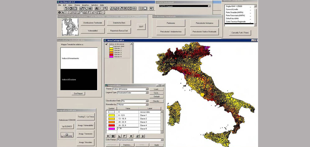
If the risk of cultural heritage loss is assumed as a criterion for the identification of priorities, the knowledge of its distribution throughout the territory is required for developing safeguard, conservation, and urban planning measures. This explains why cartographic representation of the risk level provides a solid planning tool and an immediate visualisation of the information relevant to cultural heritage survival. At the same time, a Geographic Information System becomes the best suited IT instrument for this purpose. As a result, between 1992 and 1996, the ICR started implementing the MARIS (MAppa RISchio) system, in order to allow access to planning documents for Public Administration – in particular the Superintendences engaged in the safeguard, conservation and maintenance of cultural heritage in their areas of jurisdiction.
This methodological approach derives from the experience acquired in Italy since the 1960s in the application of scientific methodologies, environmental and microclimate monitoring and Non Destructive Testing to knowledge and conservation of cultural heritage through a strategy based on damage prevention rather than traditional restoration. The MARIS data sheet model is divided into two sections: one covers property master data, using the ICCD cataloguing standards, and the other covers data on the preservation state. The MARIS GIS was built using ESRI software products for the management of basic cartography and the generation of thematic maps, and Oracle products for the creation, management and querying of the alphanumerical database. The IT processes developed to date allow both to measure the risk of loss intensity, which each property is subject to, and to acquire its distribution across Italy by means of thematic cartographic representations that can be always up to date.
The “Risk Map” is the most extensive system of alphanumeric and cartographic database that includes data concerning a very large amount of cultural assets distributed across the entire Italian territory, due to the work of property census and cataloguing carried out at central (Central Pole, ISCR, Rome) and local level (Remote Systems, Regions). The experimentation carried out until now through the survey of many artefacts, and the consequent identification of about 200 variables, has allowed to build up a system capable of evaluating, with sufficient accuracy and completeness, the “Vulnerability” index of the cultural heritage under investigation. The system, however, does not still provide a “Risk” index. This is partly compensated for by the use of overlay mapping processes which, by matching computerized maps with thematic content, allow to highlight the relationship between environmental hazard existing on the territory (e.g. due to earthquakes, floods, landslides, etc.) and the risk monuments are exposed to.
Despite some functional issues, the fact is that the “Risk Map” system is the main reference tool in the safeguard of Italian Cultural Heritage. The system consists of an archive capable of processing data and statistics for each of the 8100 Italian municipalities expandable with their provincial, regional and national aggregations. Since 1997 many Regions, in collaboration with the correlated Superintendences, have outlined their local plans. Among others, the GIS of Regione Siciliana can be mentioned, which is based on the ISCR technical data sheet and is aimed at identifying the “vulnerabilities” of each complex surveyed.
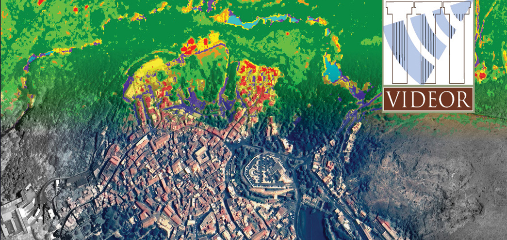
The near future development of the “Risk Map” system could be represented by the integration of thematic cartographic data with data provided by satellite remote sensing and drones. Such approach, for instance, is supported by the Cosmo-SkiMed national programme, promoted by the Italian Space Agency, and by the European project Copernicus Europe’s eyes on Earth that recently sponsored the Videor project, in order to collect important information on the territory, marine environment, atmosphere, climate change, emergency management, and security thematic areas.
To date, the Geographic Information System of the “Risk Map” turns out to be a tool of territorial government, available both to State and regional bodies, yet its potential is far from being fully understood.
VMAC – 2016