by Andrea Gaucci and Simone Garagnani
The archaeological area and the National Etruscan Museum of Marzabotto retain the best preserved Etruscan city, founded on astronomical principles around 500 BC. This settlement, whose ancient name was Kainua, has kept its original urban layout intact. However, the archaeological evidence has little visual impact, since only buildings foundations have remained. Therefore, over the years the ancient city has been a test bench for developing documentation techniques which allow us today to follow the evolutionary path from traditional survey methods to BIM models.
The potentialities of the interdisciplinary research on the site have led to the birth of the Kainua Project, which merges the fields of archaeology, architecture, engineering and informatics. The project is part of an on-going excavation activity led by the Alma Mater Studiorum – University of Bologna in collaboration with the local Superintendence and the Polo Museale dell’Emilia Romagna, and it aims at the digital reconstruction of the Etruscan city, explicitly based on the Seville Principles of Virtual Archaeology.
Step 1. From the reconstruction drawings to the digital models
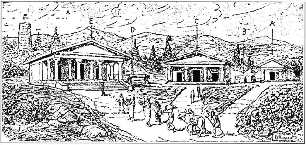
The area of the ancient city has been investigated since the middle of the 19th century, leading to the rediscovery of the urban layout, formed by streets, houses and households, and sacred buildings. The first attempts to return some buildings were made by Pericle Ducati, who suggested a hypothetical reconstruction restitution of the acropolis, and by Guido Achille Mansuelli, who proposed a reconstructive drawing of the city blocks.
Only in recent decades did modern methods of stratigraphic excavations raise greater awareness of the archaeological reconstruction of the buildings. Since 2000, during the events of Bologna European Capital of Culture, Giuseppe Sassatelli introduced digital restitution as a scientific and dissemination tool in the reconstruction of the Etruscan city.
Step 2. The archaeology of the non-existent
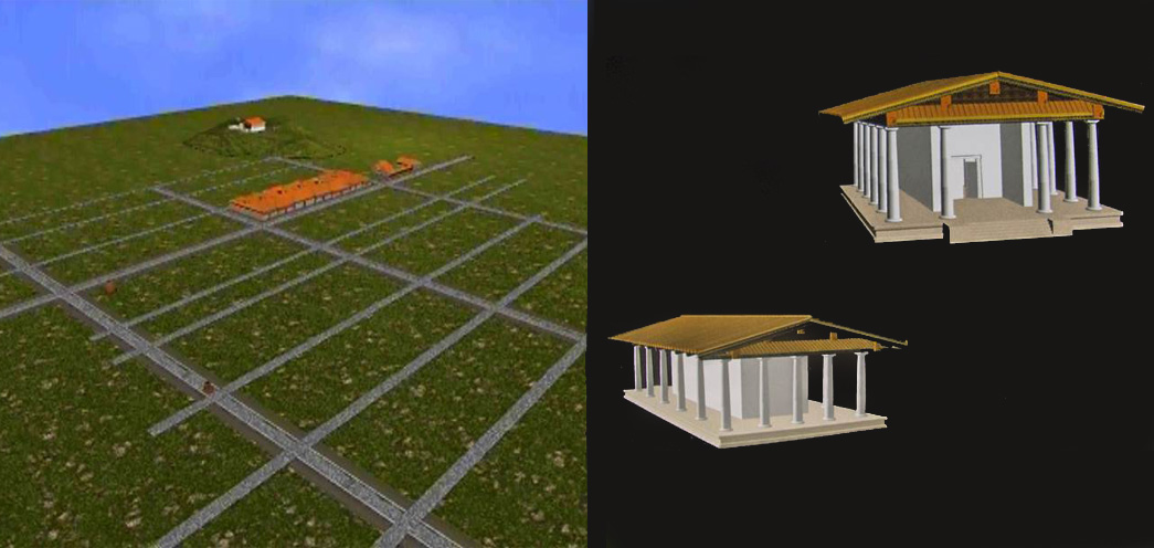
The reconstruction of the Kainua urban texture started from the Digital Terrain Model (DTM). Thanks to the survey of the acropolis (using terrestrial laser scanning techniques) and the open fields in the lower town (using digital photogrammetry through UAV technologies), a multi-scalar DTM of the archaeological area was designed and it was embedded in the Reno Valley DTM, a pioneer experiment carried out in 1993 by CINECA.
The elaboration of the digital model was based on the available archaeological data and on the results of the excavations carried out by Bologna University since 1988, which provided a term of comparison for other poorly-known contexts of the Etruscan city. An illustrative example is the study and reconstruction of the buildings of Regio IV, insula 1, the so-called “isolato Mansuelli”, whose excavations were started by Paolo Enrico Arias and Guido Achille Mansuelli between the 1950s and the 1960s.
The Kainua Project adopts two distinct methodologies: the former is meant to be a knowledge dissemination media useful for virtual representations in museums, exhibitions and on the archaeological site, the latter is meant to become a complex database framework designed for experts. From a digital perspective, this second approach, which considers both visualization and data mining approaches, is very similar to the Building Information Modeling (BIM) process that can be applied during the building design process of new contemporary facilities. Recently, thanks to the advantages of the Historic Building Information Modeling (HBIM) – a BIM-based approach applied on the existing domain – BIM methods have been appreciated for monumental heritage documentation and for the archaeology of non-existing constructions.
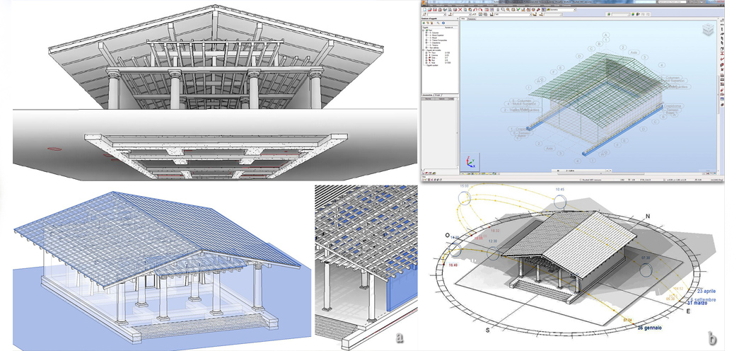
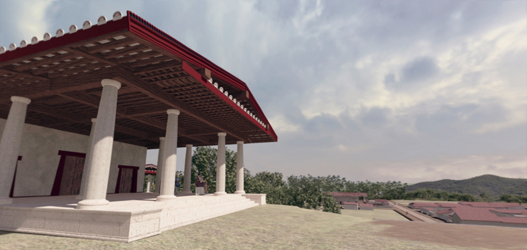
In the case of the Tuscanic Temple of Uni, a methodological process named ArchaeoBIM was defined. As in ordinary BIM models, in an ArchaeoBIM semantic model individual elements keep the memory of their associated multidisciplinary information, however the authoring process is considerably innovative. By complementing a historical approach and simulating static and resistance of the sacred building in different weather, thermal or lighting conditions, ArchaeoBIM applies reconstructive technologies to formulate reflections on the architectural credibility of the virtual model, monitoring all the steps of analysis up to the final simulation. This approach perfectly fits the paramount issue of validation of virtual models, as stated in the 8th Principle of the Seville Charter.
The ArchaeoBIM procedure was based mainly on the semantic and functional synthesis of architectural components replicated in the digital domain: the meaning of those digital elements can be compared to linguistics. Like letters and words, architectural elements respect a more general grammar, which expresses their order and function. An ArchaeoBIM model allows the semantic reconstruction of components by specifying their role both from a compositional point of view and from a functional perspective (morphology, used material, layering technique, resistance to stress, durability of the elements, etc.).
Step 3. A challenge in complexity
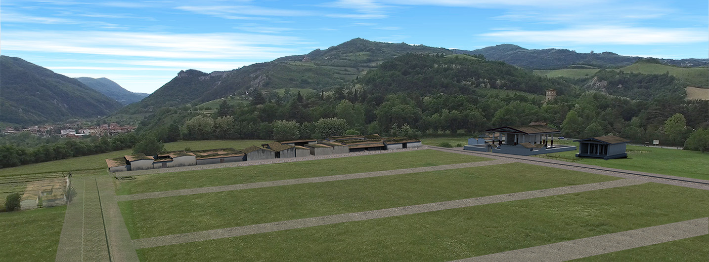
In order to reconstruct the digital cityscape, all archaeological data was collected and managed in an open source GIS (QGIS), which is the core platform of the 3D GIS system conceived as an advanced tool for scholars and experts. Primary and secondary urban roads with public and private sewer form the infrastructural platform on which the digital models of all the buildings were placed. The river terrace, where the Etruscan city was formerly planned and built, has been involved in an articulated campaign of geophysical surveys. Its results, together with excavation data, led Elisabetta Govi to formulate an interpretative scheme of the buildings’ modules and their layout within the blocks, recreating wide areas of the city according to philological criteria.
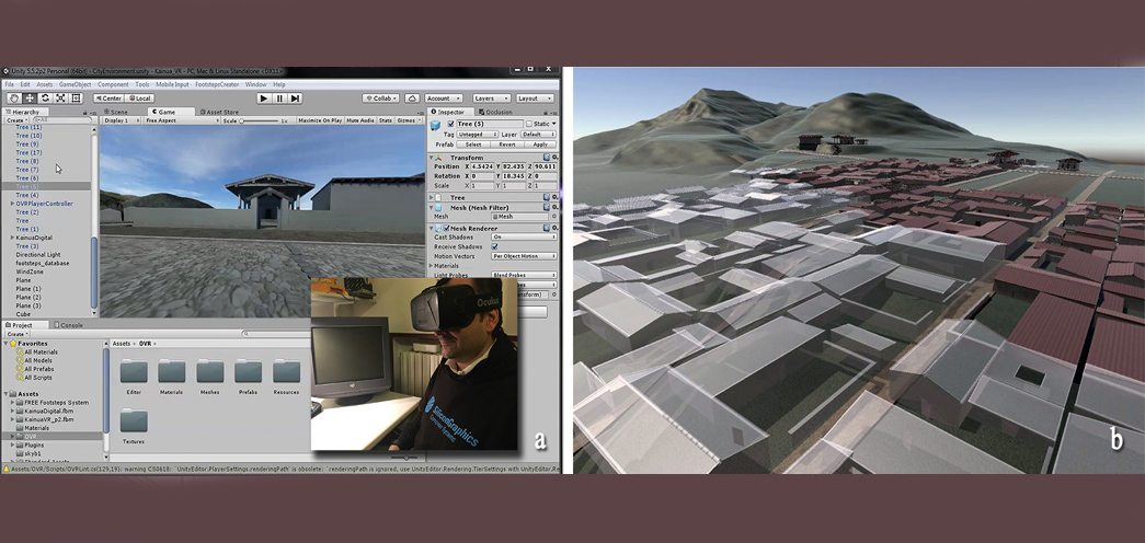
The virtual models of buildings and urban environment refer to the age of greatest development of the city, which dates back to the 5th century BCE. The interdisciplinary nature of the interpretative process is worthy of note, as it is not limited to interaction with disciplines more closely related to Virtual Archaeology, but it involves the entire complex of studies, which contribute to the understanding of the context and the building materials (i.e. palaeobotany, archaeometry, geophysics, archaeozoology). The model is also the basis for a more updated onsite fruition system of the archaeological area for a wider audience. A user-friendly system based on stationary immersive views of the virtual model to be used in long visits, such as Panoramic Virtual Reality, compensates the lack of appropriate markers and effective computational resources for Augmented Reality. A narrative plot of the social life and key episodes of the city’s history, such as the foundation rite, will allow visitors to engage emotionally during the visit. At the same time, reconstruction through the ArchaeoBIM process of the whole city will give as a result a navigable 3D database as well as a basis to experiment on a wider scale the physical simulation of ancient structures.
VMAC – 2017