by Nicola Masini and Rosa Lasaponara
A brief history of satellite remote sensing in archaeology
Since the end of the Nineteenth century, aerial photography has been the most widely used technological device for surveying surface archaeological remains, as well as for revealing land alterations and detecting underground archaeological structures through the reconnaissance of the so-called “soil” and “crop marks”.
In 1972 the multispectral scanner on board of Landsat opened a new era for remote sensing applications, although not yet suitable for archaeological purposes. During the last twenty years, the use of Spatial Earth Observation technologies in archaeology has strongly developed thanks to: i) the improvement of spectral and spatial resolution of satellite sensors; ii) the availability of user-friendly software and routines for data processing and analysis; iii) the archaeologists’ interest in the dynamics of human frequentation in relation to environmental changes.
Satellite remote sensing technologies have triggered improvements in archaeological research and developments of new tools in archaeological prospection from discovery to monitoring, from documentation to preservation.
1970s: the turning point of spatial technology
On May 25, 1972 the last satellite of the Corona program was launched. The Corona Program consisted in a series of strategic reconnaissance satellites operated by American CIA to take photographs of the Soviet Union, the People’s Republic of China and other regions of Eastern Europe and the Middle East, starting from June 1959.
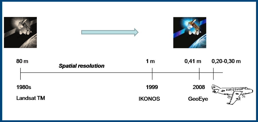
Only two months after, on July 23, another event marked a turning point in spatial technology: the launch of the first Landsat satellite equipped with a multispectral scanner (MSS). The event opened the era of Earth Observation for civil use. But MSS 80m resolution was not adequate for archaeological applications and only proved useful in providing information called for by palaeo-environmental studies.
On the contrary, after the declassification of the Corona Program in 1992, archaeologists have used this precious dataset to detect changes and discover unknown sites, mainly in the regions of the Middle East, where intelligence satellite photographs were available at higher spatial resolution.
1980s: pioneer satellite archaeologists of NASA
The birth of satellite archaeology is to be ascribed to NASA and other US universities scientists who contributed both directly and indirectly to furthering the use of satellite and suborbital platforms as archaeological research tools. Among the pioneers of satellite remote sensing and archaeology in the United States, Scott Madry, Jay Johnson, James Wiseman and Tom Sever were prominent.
Early applications of satellite data for studies on past human activities were attempted starting from the 1980s using the Thematic Mapper (TM), which was the highest (30 m) spatial resolution sensor available at that time for civilian applications. Using TM data, some success was achieved in landscape archaeological investigations, to locate prehistoric archaeological sites, and also in palaeo-environmental studies.
Moreover, these early studies highlighted the need to set up proper image processing techniques and modelling to predict areas of potential archaeological interest. First promising results have also been provided by satellite active sensors in arid environments thanks to their capability to penetrate sandy surfaces. In 1982 Shuttle Imaging Radar (SIR-A) allowed to reveal unknown buried valleys, and possible Stone Age occupation sites in eastern Sahara.
1990s: from Landsat to Corona
In the USA the integration of TM and the ETM+ data acquired from Landsat 5 and 6 platforms with multispectral airborne imagery, from the visible spectrum to thermal infrared, allowed to enlarge the arena of archaeological features to detect a wide gamut of evidence: from old roads to ancient land divisions, and from relict agricultural systems to geo-archaeological patterns.
In Europe, scientists exploited the spectral resolution of satellite data (TM , ETM+ and SPOT5) and the higher spatial resolution (2-4 m) of declassified Russian and American satellite photographs, in order to detect changes as well as to discover unknown sites, mostly in Middle Eastern and European regions.
As an example, we can quote the detection of archaeological evidence in the Greek and Roman city of Zeugma on the Euphrates in Turkey, the identification of ancient irrigated and cultivated areas in Yemen, the reconnaissance of archaeological evidence near a hill fort in Hampshire (UK), dating back to the Iron Age.
21st century
In 1999 the launch of IKONOS, the first commercial VHR satellite sensor, opened new perspectives in the field of archaeogeophysics. Since 1999 the spatial resolution has grown significantly, thus providing valuable support for site discovery by means of soil/crop mark detection. The “great run” of commercial satellite technology for reaching the resolution of aerial images seems to have come to an end with GeoEye1 (launched in September 2008) which provides 41 cm panchromatic and 1.65 m multispectral imagery.
In the last decade the use of effective data processing procedures, from classification methods to spectral indices, from principal component analysis to convolution, opened new ways to set up an automatic (without human intervention), or at least semiautomatic (with human intervention), approach for the reconnaissance of archaeological evidence and site/landscape change detection, like the tells detected in Northern Mesopotamia and a large buried settlement identified by ITACA mission in the Nazca riverbed in Peru.
VMAC – 2016